Why it works
Soil, rock and ice all transmit some radio energy. Whenever there's a boundary between materials of different dielectric constant (a pipe in soil, a void in concrete, water under ice), some energy reflects. Map those reflections vs. depth and you get a vertical slice.
Frequency vs. depth
High frequency (1–3 GHz) gives centimetre resolution but penetrates only a metre or two. Low frequency (50–100 MHz) reaches tens of metres but resolves only large features. Glacier-sounding radars run as low as 5 MHz.
Archaeology and forensics
GPR is now standard for surveying before any major dig. Stonehenge, Vesuvius, the Cahokia mounds — all imaged before a shovel touches the ground. Forensic teams use GPR to find unmarked graves; it's faster and less invasive than digging.
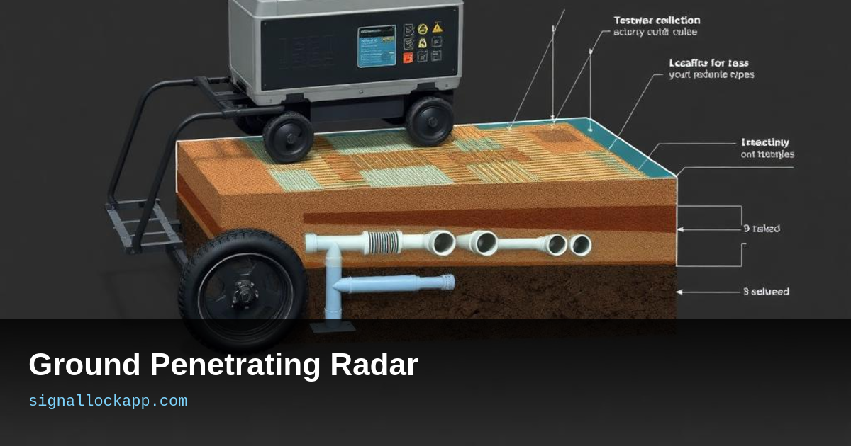
Construction and infrastructure
Every drilled hole in a city sidewalk gets a GPR sweep first to find power, gas and fibre. Bridge inspectors use GPR to map rebar corrosion. The same physics, very different stakes.
The Dielectric Contrast and Velocity
While shape and size determine what a GPR operator sees, the fundamental constraint is the dielectric constant of the medium. Radio waves travel at roughly 300,000 kilometers per second in a vacuum, but soil and concrete slow them down significantly. In dry sand, the constant (relative permittivity) is around 3 to 5, allowing for fast propagation and clear imaging. However, wet clay can have a dielectric constant as high as 40, which absorbs signal energy and converts it into heat. This explains why GPR performance drops sharply after heavy rainfall; the water molecules interfere with the signal’s path, effectively blinding the sensor to deeper targets.
To calculate the actual depth of a buried object, technicians must estimate the signal velocity through the specific material. If the dielectric constant is misjudged, a pipe that appears to be two meters deep might actually sit at one meter. This is why pros often use hyperbola fitting—analyzing the arc of a reflection as the antenna passes over a point—to calculate the local velocity in real-time. Without this calibration, the resulting slice is merely a visual approximation. Understanding this relationship between moisture, material density, and wave speed is what separates a casual user from a professional geophysicist.
Planetary Missions and Glaciology
GPR technology is not limited to terrestrial soil; it is a critical tool for extraterrestrial exploration. The Mars Express orbiter utilized the MARSIS instrument, a low-frequency radar that detected signs of liquid water beneath the Martian south polar ice cap in 2018. By using frequencies in the 1.8 to 5.0 MHz range, the system could penetrate kilometers of frozen CO2 and water ice. Similarly, the Perseverance rover carries the RIMFAX (Radar Imager for Mars' Subsurface Experiment), which provides a high-resolution view of the geological layers beneath the Jezero Crater, helping scientists select samples that might contain ancient microbial life.
On Earth, the most extreme application of this tech occurs in deep-ice glaciology. Modern airborne GPR systems can map the bedrock topography beneath the Antarctic ice sheet, which is often more than 3,000 meters thick. These surveys are vital for climate modeling, as they reveal the friction points where glaciers are anchored to the continent. By measuring the intensity of the return signal from the base, researchers can determine if the interface is dry rock or lubricated by subglacial meltwater. This data is essential for predicting how quickly ice sheets might slide into the ocean as global temperatures rise.
Phase Shifts and the Phase Inversion Phenomenon
A common technical misunderstanding is that GPR simply measures the time-of-flight for a return pulse. In reality, the polarity of the reflected wave reveals the nature of the target. When a pulse moves from a low-dielectric material (like dry sand) to a high-dielectric material (like a water-filled metal pipe), the phase of the wave inverts. Conversely, moving from a high-density material to a lower-density void results in no phase shift. Skilled analysts examine the 'wiggle' of the waveform to distinguish between a solid granite boulder and a hollow burial chamber, allowing for identification without physical core sampling.
The velocity of the signal is also dictated by the relative permittivity of the medium, ranging from 0.3 meters per nanosecond in air to as little as 0.03 meters per nanosecond in water. Because moisture drastically slows the pulse, any estimation of depth requires a precise calibration of the local soil's dielectric constant. Without this step, a pipe estimated to be one meter deep might actually be at two meters, leading to dangerous errors during excavation. This dependency on moisture explains why GPR performance degrades significantly in clay-rich soils, where high conductivity attenuates the signal into heat.
The 1972 Apollo 17 ALSE Experiment
While often viewed as a terrestrial tool, one of the most significant historical milestones for GPR occurred during the Apollo 17 mission in December 1972. The Apollo Lunar Sounder Experiment (ALSE) used a three-frequency radar system to probe the lunar subsurface from orbit. This was the first time subterranean mapping was attempted from a spacecraft, revealing geological layering and basaltic flows deep beneath the lunar mare. The data collected proved that GPR could operate in a vacuum over massive distances, paving the way for the later discovery of subglacial lakes on Mars by the MARSIS instrument.
This experiment utilized a dipole antenna system spanning 20 meters, operating at 5, 15, and 150 MHz. By analyzing the time-delay and Doppler shift of the pulses, scientists mapped the structural discontinuity of the Moon's crust down to 1.6 kilometers. The success of ALSE transitioned GPR from a niche civil engineering tool into a fundamental instrument for planetary science. It demonstrated that radar could act as a virtual shovel, uncovering the chronological history of planetary formation without requiring a landed drilling rig, a methodology that remains the gold standard for extra-planetary exploration today.